New projects
Subsales
Rentals
 MoreMoreMore
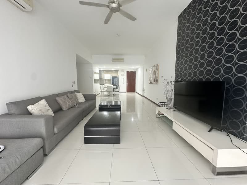
Suasana Sentral Loft, Kl SentralSuasana Sentral Loft — Jalan Stesen Sentral 5 — for Rent
1 of 5
Price
RM4,500
Bedroom

3 + 1
Bathroom

3
Room type
Whole unit
Built-up
1,580 sqft
Carpark

1
Get the latest offer for this unit
Home details
Address
- 9, 50450 Jalan Stesen Sentral 5, Kuala Lumpur
Type
Condominium
Title
Strata
Tenure
Freehold
Room type
Whole unit
Built-up size
1,580 sqft
Carparks
1
Facilities
Ground Floor / Common Facilities
1
24-hour security
2
Parking
3
Barbecue area
4
Jacuzzi
5
Playground (indoor & outdoor)
6
Wading pool
Level 38 (Tower A)
1
Sky club
2
Sky gym
3
Lounge
Nearby points of interest
- school
Valley International School
226 m
- school
Sekolah Menengah Kebangsaan Vivekananda
306 m
- school
Sekolah Jenis Kebangsaan (Tamil) Vivekananda, Kuala Lumpur
340 m
- school
Havil International School
401 m
- school
Sekolah Jenis Kebangsaan (Cina) St. Teresa Brickfields
452 m
- school
Sekolah Kebangsaan Brickfields 1 & 2
498 m
- school
Global Indian International School
500 m
- school
Sekolah Kebangsaan La Salle (1) Brickfields
501 m
- school
Sekolah Kebangsaan St. Teresa Brickfields 1 (M)
536 m
- school
Sekolah Kebangsaan (P) Methodist 1 (1) Brickfields
582 m
1–5 of 10
Crime intelligence
HighIPD Dang Wangi · 2023
Total crimes (2023)
993
convictions
vs. Kuala Lumpur avg
+23%
above state median
Most common
Theft other
49% of total
Density — crimes per 100k residents
284
per 100k · population ~350,000
This district
284
Kuala Lumpur median
231
Coverage area
Bukit Bintang, KLCC, Jalan Dang Wangi, Masjid India, Ampang Park, Puduraya
IPD boundaries do not correspond to neighbourhood or administrative boundaries
Crimes by category (2023 convictions)
Theft other
490
Theft vehicle motorcycle
185
Robbery gang unarmed
80
Robbery solo unarmed
79
Break in
59
Annual trend (IPD Dang Wangi)
2914
2019
2040
2020
1411
2021
1128
2022
993
2023
District crime index
90 / 100 · 67th percentile in Kuala Lumpur
Low
Moderate
High
Conviction-based data from PDRM — not reported incidents. Unreported crimes may not be reflected. Police district boundaries differ from administrative mukim boundaries.
Source: Royal Malaysian Police (PDRM) via data.gov.my · CC BY 4.0
Area flood risk
High riskJalan Stesen Sentral 5
Based on the nearest river monitoring station. This reflects flood risk in the surrounding area, not the specific property.
Current discharge
0.9 m³/s
Above threshold
Mean discharge
2.1 m³/s
30-day average
Max discharge
20.8 m³/s
30-day peak
Last flooded
1 Sept 2025
Past 2 years
Flood frequency
4 events
Past 2 years
Monthly flood risk profile
Jan
Feb
Mar
Apr
May
Jun
Jul
Aug
Sep
Oct
Nov
Dec
Low
Moderate
High (monsoon)
DID InfoBanjir tracks water levels in real time. Set up alerts at publicinfobanjir.water.gov.my
Source: Jabatan Pengairan dan Saliran (DID) Malaysia · Open-Meteo