New projects
Subsales
Rentals
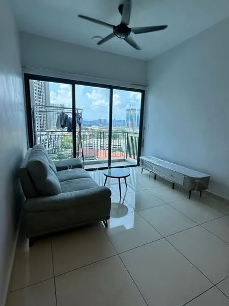
The Link 2 Residences, Bukit JalilThe Link 2 Residences — Bukit Jalil Highway Jalan Jalil Perkasa 3 — for Rent
1 of 5
Price
RM2,600
Bedroom

3
Bathroom

2
Room type
Whole unit
Built-up
971 sqft
Carpark

2
Get the latest offer for this unit
Home details
Address
Bukit Jalil Highway Jalan Jalil Perkasa 3, Bukit Jalil Highway Jalan Jalil Perkasa 3, Kuala Lumpur
Type
Apartment
Title
Residential
Tenure
Freehold
Room type
Whole unit
Built-up size
971 sqft
Carparks
2
Facilities
Residential Facilities
1
Infinity pool
2
Gymnasium
3
Landscaped gardens
4
Children's playground
5
Multi-purpose halls
6
BBQ pits
Nearby points of interest
- school
Sekolah Menengah Kebangsaan Bukit Jalil
723 m
- school
Sekolah Kebangsaan Bukit Jalil
813 m
- school
Sekolah Jenis Kebangsaan (Cina) Lai Meng
1.3 km
- school
Kingsgate International School
1.6 km
- school
Sekolah Sukan Bukit Jalil
1.7 km
- school
Sekolah Menengah Kebangsaan Bandar Baru Seri Petaling
1.7 km
- school
Sekolah Menengah Kebangsaan Seri Saujana
1.8 km
- school
Sekolah Kebangsaan Seri Indah
1.8 km
- school
Sekolah Kebangsaan Bandar Baru Seri Petaling 2
1.8 km
- school
Sekolah Kebangsaan Seri Saujana
1.9 km
1–5 of 10
Crime intelligence
LowIPD Cheras · 2023
Total crimes (2023)
758
convictions
vs. Kuala Lumpur avg
−6%
below state median
Most common
Theft vehicle motorcycle
27% of total
Density — crimes per 100k residents
168
per 100k · population ~450,000
This district
168
Kuala Lumpur median
180
Coverage area
Cheras, Pudu, Salak Selatan, Sungai Besi, Bukit Jalil, Desa Petaling
IPD boundaries do not correspond to neighbourhood or administrative boundaries
Crimes by category (2023 convictions)
Theft vehicle motorcycle
203
Theft other
191
Theft vehicle motorcar
124
Break in
76
Causing injury
51
Annual trend (IPD Cheras)
1635
2019
1295
2020
1058
2021
849
2022
758
2023
District crime index
69 / 100 · 17th percentile in Kuala Lumpur
Low
Moderate
High
Conviction-based data from PDRM — not reported incidents. Unreported crimes may not be reflected. Police district boundaries differ from administrative mukim boundaries.
Source: Royal Malaysian Police (PDRM) via data.gov.my · CC BY 4.0
Area flood risk
Low riskBukit Jalil Highway Jalan Jalil Perkasa 3
Based on the nearest river monitoring station. This reflects flood risk in the surrounding area, not the specific property.
Current discharge
N/A
Normal
Mean discharge
N/A
30-day average
Max discharge
N/A
30-day peak
Last flooded
No recent floods
Past 2 years
Flood frequency
None recorded
Past 2 years
Monthly flood risk profile
Jan
Feb
Mar
Apr
May
Jun
Jul
Aug
Sep
Oct
Nov
Dec
Low
Moderate
High (monsoon)
DID InfoBanjir tracks water levels in real time. Set up alerts at publicinfobanjir.water.gov.my
Source: Jabatan Pengairan dan Saliran (DID) Malaysia · Open-Meteo